

Why Tiwanaku Rewrites Everything We Thought About Andean Power
Between 500-1100 CE, Tiwanaku engineers conquered frost, altitude, and drought through raised-field agriculture that modern science is still trying to fully understand

Stand on the windswept plateau at 3,850 meters and your lungs burn within minutes. Frost forms on stones most nights of the year. Lake Titicaca stretches blue and massive to the north, mountains loom sacred and snow-capped in all directions. Walking these ruins changes how you understand pre-Columbian civilization—not just because of the monumental stones, though those impress, or the famous Gateway of the Sun with its enigmatic carvings. What transforms your thinking is realizing that between roughly 500 and 1100 CE, communities here didn’t merely survive, they developed sophisticated water management systems that enabled high-altitude agriculture, producing food efficiently enough to sustain a substantial population. Modern researchers study these raised fields with computer modeling to understand their thermal and hydraulic engineering.
Tiwanaku raised-field berms at high altitude incorporated multi-layered, moist soils and surrounding canals to store heat from daytime solar radiation, releasing it at night to help protect crops from frost. This was not trial and error, it represents deliberate application of physical principles at a civilization-building scale.
Engineering Frost Out of the Equation
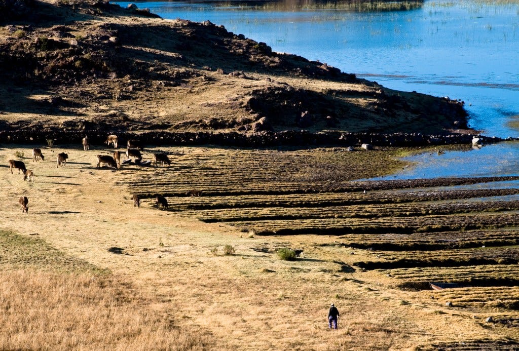
Fields were large planting platforms ranging from 5 to 20 meters in width and up to 200 meters in length, with artificially raised mounds separated by shallow canals filled with water. Walking along reconstructed fields today, the ingenuity of the design becomes clear. Canals were not just for irrigation—they functioned as thermal buffers.
During Altiplano days, intense solar radiation heats water in the canals. At night, when temperatures often drop below freezing, the stored thermal energy radiates toward crops on the elevated platforms, helping reduce frost damage. Recent finite-element analyses, including simulations using ANSYS, confirm that the combination of raised berms and water-filled channels created measurable frost protection, demonstrating sophisticated environmental engineering based on careful observation and experience.
But thermal regulation was just one benefit. Raised platforms provided superior drainage during the intense rainy season from November through March. Between the raised rows, ditches allowed rainwater to flow without harming crops, while the elevated soil helped protect plants from cold nighttime temperatures. Slower erosion rates preserved soil fertility, and aquatic plants growing in the canals could be harvested as a nutrient-rich fertilizer, creating a sustainable system that maintained productivity for centuries.
Recent archaeological research documents approximately 19,000 hectares of raised fields in Tiwanaku’s core region. Calculating potential food production from this area highlights the sophistication of the system. Under ideal conditions, with double cropping and full utilization, these fields could theoretically support up to 760,000–1,480,000 people, though more conservative estimates suggest a population in the hundreds of thousands.
Maintaining and organizing fields on this scale required coordination. Did Tiwanaku’s elite centrally manage this agricultural infrastructure, or did local communities organize it cooperatively? Evidence suggests a hybrid model is plausible, indicating a social system more nuanced than a simple top-down hierarchy.
Economic Networks Built on Water
Tiwanaku’s ceremonial center was integrated with an elaborate hydraulic network, with canals connected to nearby wetlands and rivers. Understanding this system has helped archaeologists appreciate how water management shaped the organization of labor and economic activity. Water was not merely infrastructure, it played a central role in supporting agriculture and sustaining communities.
Managing roughly 19,000 hectares of raised fields required large-scale coordination. Questions remain: who determined canal placement, and how were disputes over water access resolved? Archaeological evidence from residential compounds surrounding the ceremonial core shows neighborhoods with specialized craft production, including pottery workshops, textile production areas, and food storage facilities. This suggests significant economic differentiation beyond simple farmer-elite divisions, reflecting a complex, multi-layered society.

Llama and alpaca herding complemented agriculture, with llamas especially important for transporting staple and prestige goods. Caravans carried ceramics, textiles, and copper tools across long distances, linking the Altiplano with Pacific coastal valleys and eastern lowlands.
Tiwanaku’s location between Lake Titicaca and the dry highlands provided access to fish, wild birds, plants, and grazing grounds for camelids. Underwater archaeology in Lake Titicaca has uncovered ritual deposits, including exotic items such as pumas carved from lapis lazuli, turquoise pendants, and thorny oyster shells, likely originating from distant regions. Many of these deposits appear to have been deposited from boats, with radiocarbon dating placing them roughly between the 8th and 10th centuries CE.
These offerings were part of extended pilgrimage routes. Travelers would make multiple stops of ritual significance along the way, with the journey from Tiwanaku to the Island of the Sun estimated to take around two weeks. Economic and religious functions were closely intertwined throughout these activities.